An upcoming weather pattern means the world may be heading into a warming period that will likely impact precipitation in Canada, possibly causing floods or droughts.
Earlier this month, the United Nations' weather agency said there is a two-out-of-three chance of a worldwide "temporary" warming period beginning some time over the next five years.
The weather phenomenon is called El Nino, and it works in tandem with La Nina. Both are naturally occurring weather patterns.
El Nino is a warming period that lasts between nine and 12 months, while La Nina is a cooling effect that can last up to a few years, the U.S. National Oceanic and Atmospheric Administration (NOAA) website says.
The planet has been under a cooling influence from La Nina for the last several years, but new data suggests El Nino is returning, which will have an effect on weather including in Canada over its duration.
"It's very likely (weather) systems are going to be a little bit more intense," Richard Dewey, associate director of science with Ocean Networks Canada, told CTVNews.ca in an interview. "With more heat and energy in the weather system, the ocean and the atmosphere, storms and natural variabilities could be more intense."
Depending on the strength of the heat, some areas will face more precipitation, while others experience severe drought, Dewey said.
As the effects of El Nino spread across the world, the phenomenon can temporarily push the average global temperature 1.5 C above pre-industrial levels, making extreme weather events associated with the rise possible. The UN believes there is a 66 per cent chance the world will have a year that averages 1.5 C warmer than the mid-19th century.
WHAT CONTROLS CANADA'S WEATHER?
Weather in Canada is largely influenced by the jet stream, a "narrow band of strong winds" about 10 kilometres above the Earth, the Environment and Climate Change Canada website reads.
It marks the divide between cold air from the north and often warmer winds from the south. Although the atmosphere holds many different air patterns, the jet stream is important due to the speed of the winds, which are between 160 and 320 km/h. The winds move west to east.

The above graphic was made using jet stream maps from June 1 and 2, 2023 from Environment Canada. (Created by JesseTahirali/ CTVNews.ca.)
____________________________________________________________________________________________________________________________________________________________
How the jet stream works is essential to understanding Canada's weather patterns, as it has the strength to push low- and high-pressure systems across the country, often dictating temperature and precipitation.
If the band is upward, warmer air travels into Canada. If it is downward, cooler air moves in. Often it resembles an up-and-down line with low- and high-pressure systems pinching along.
HOW DOES EL NINO INFLUENCE THE JET STREAM?
When El Nino comes into the picture, its influence can severely impact the jet stream, thus creating different weather patterns across Canada.
According to the NOAA, when the jet stream is under El Nino conditions, it makes northern areas like Canada dryer and warmer than usual.
Warmer air from El Nino pressing into the country, Dewey says, can create an Omega-blocking pattern in the jet stream.
"On the backside of an Omega blocking pattern, you have a big depression of the polar air, so cold air is much deeper south than normal," Dewey said. "And sometimes these patterns just sit there for a long time."
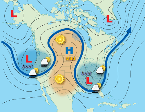
This type of blocking pattern can bring heat to some areas and cool, wet temperatures to others.
The year of the devastating Fort McMurray fires in 2016 was near the end of an El Nino sequence. At the time, hot, dry weather was sitting over northern Alberta in the Omega blocking pattern, an article by NASA reads.
This weather event was one of the hottest on record, but did not surpass what the Canadian government calls the "great El Nino of 1997-98."
But when it comes to what exactly this episode of El Nino will bring, experts say it's hard to know for sure.
Dewey says predicting weather is better with the help of technology, but it is not good enough to depict how strong El Nino could be this year.
"We are still only good (at predicting weather) about seven days out," he said. "You can look up a 14-day forecast (but) it starts to get a little shaky. So seasonal forecasting our weather is still a skill under development."
WHAT SEVERE WEATHER CAN CANADA EXPECT?
If the Omega-blocking pattern persists during an El Nino year, the jet stream will hold cool, wet weather over some areas and dry, hot temperatures over others.
Too much of either for one region can impact growing seasons, or cause floods or droughts.
El Nino also has an influence over water, which can increase or decrease the likelihood of storms off Canada's coasts.
Because El Nino can raise the atmospheric temperature, it can also have an impact on the world's oceans. Dewey says for tropical storms to form either in the Atlantic or Pacific oceans, temperatures and wind need to be just right.
"(The ocean) has to be above 30 degrees to get intense evaporation," he said. "So you accelerate that evaporation, you accelerate the amount of moisture that's put into the atmosphere because of the winds, and it feeds itself and grows into a tropical storm."
Dewey is hesitant to correlate increased hurricanes or typhoons during El Nino years, saying the research into this is ongoing.
"El Nino and hurricanes, they're both getting a little bit more intense as the oceans warm, but an El Nino year doesn't indicate yet that the hurricane season is going to be more intense," he said. "They're both being influenced by climate change, so it's possible we'll discover over the next decade, even now, that yes, El Nino (years) do start to affect hurricanes. But that linkage is not confirmed yet."
The NOAA says research seems to point in the direction that El Nino "favours" stronger activity in the Pacific and suppresses storms in the Atlantic.
Although the predictability of these storms is difficult, scientists are largely in agreement that human impact on the planet is increasing severe weather in Canada and across the world.
"The equatorial, the high latitudes, the Arctic, have all been going through the steady march of climate change, and how it's going to impact these natural oscillations like our weather patterns, the storm tracks, the jet stream and El Nino and La Nina are really quite complicated," Dewey said. "But we do anticipate that by shifting the whole system up with more energy and more heat, it's very likely these systems are going to be a little bit more intense"


